


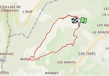
Mont Chery / Mont Caly (A/R)

Jamyfredo
User

Length
8 km

Max alt
1819 m

Uphill gradient
481 m
Km-Effort
14.5 km

Min alt
1351 m

Downhill gradient
482 m
Boucle
Yes
Creation date :
2025-03-12 09:19:00.0
Updated on :
2025-03-12 09:19:02.207
2h17
Difficulty : Medium

FREE GPS app for hiking
 SityTrail
IGN / Geographical institutes
SityTrail Plus
The world is yours!
About
Trail Walking of 8 km to be discovered at Auvergne-Rhône-Alpes, Upper Savoy, Les Gets. This trail is proposed by Jamyfredo.
Positioning
Country:
France
Region :
Auvergne-Rhône-Alpes
Department/Province :
Upper Savoy
Municipality :
Les Gets
Location:
Unknown
Start:(Dec)
Start:(UTM)
319276 ; 5115080 (32T) N.
Comments